An Axis of Human Ecology
—core studio in the 1st year of the MLA program
Washington University in St. Louis
Spring 2021
Teaching Assistant: Weicong Huang
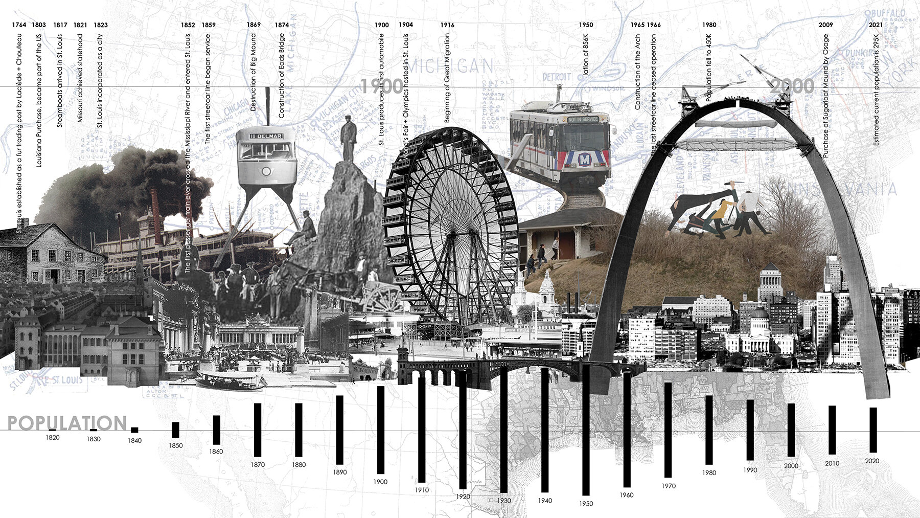

Kaiti Burger’s Timegraph and Ideogram depicting the history of the colonization of the City of St. Louis.
The Studio
Some modes of landscape architecture preserve historical values, while others pursue emerging values. Some public spaces represent how values change over time, due to the rapid transformation of urban renewal. One such symbolic space is the Gateway Mall in St. Louis—the string of small parks that extends westwardly from The Gateway Arch. Solidified in the monument by Eero Saarinen and the park by Dan Kiley, is the celebration of American ‘Manifest Destiny,’ and the role of St. Louis in that colonial project. Therefore, the Gateway National Park and the Gateway Mall are highly charged landscapes. Many designers and planners have formed and reformed these spaces over generations, communicating shifts in people-environmental relationships over the last century. At the same time, these symbolic landscapes are open for criticism, of their colonial history, and ripe for new landscape architecture to mark emerging relationships. How might future generations reconfigure these symbols?
This studio uses the Gateway Mall to question, and perhaps pushes against, the ideas, symbols, and relationships embedded in this urban renewal gesture and its many-layered pieces of landscape architecture. First, students select one territory, from the big ideas, false dichotomies, and human desires/fears that drive change in our field—aesthetics, publicness, monumentality, globalization, futurism, nature, and colonization. Studying the landscape architecture precedents found on this monumental axis supports this theoretical study. Students find harmony and dissonance between the history of landscape architecture and our own ‘ecological design’ era, by intersecting these ideas with the values embedded in the Green New Deal—soil health, biodiversity, waste, water systems, decarbonization, sustainable transit, rethinking urban fabric, local economy, heritage, and inclusivity.
Then students continue getting to know St. Louis, through a series of GIS-generated, but also imaginative, mappings. These drawings, in conjunction with studio conversation and critique, help students to home in on and hone their site on the Gateway Mall, or adjacent to this axis. Next, generative drawings intersect the big ideas from the history of landscape architecture with the contemporary ideas from the Green New Deal. Conflation, multiplication, re-ordering, and re-scripting help students experiment and assess site design in process (over and over again).
Midterm review help students test how their site designs communicate the historical and contemporary values at play in their proposals. Students decide how the design honors history, challenges problematic notions or adds new values. When the students become more confident about the definition of their site design, they begin grappling with urban connectivity, social contingency, and environmental flows. This adjusts their big ideas and schematic designs, again.
By the end of the semester, the students have a site design that intersects the Gateway Mall, occupying some portion of the existing string of parks. The projects may be understood as a counter-axis (more north-south), could be rhizomatic, or may be acupunctural. The site is defined by the student. The interventions on this symbolic axis will go beyond sculptural monuments; these should be site designs, because landscape itself can communicate human values. At the same time, landscape is also always more than that. So, students learn and wield an arsenal of urban components from streetscape design, urban infrastructure, and ecological assemblages.
Timegraph and Ideogram Drawings
These imaginative drawings helped the students document what they are learning about the Gateway Mall, St. Louis, and each student’s dialectical study. We took in some history and engage designers to understand what has driven ideas in landscape architecture, urban design, and architecture since the inception of the Gateway Mall. Students read and diagramed ideas, collected historic images, and formulated two types of drawings to set up a particular context for their critical landscape architecture design work.
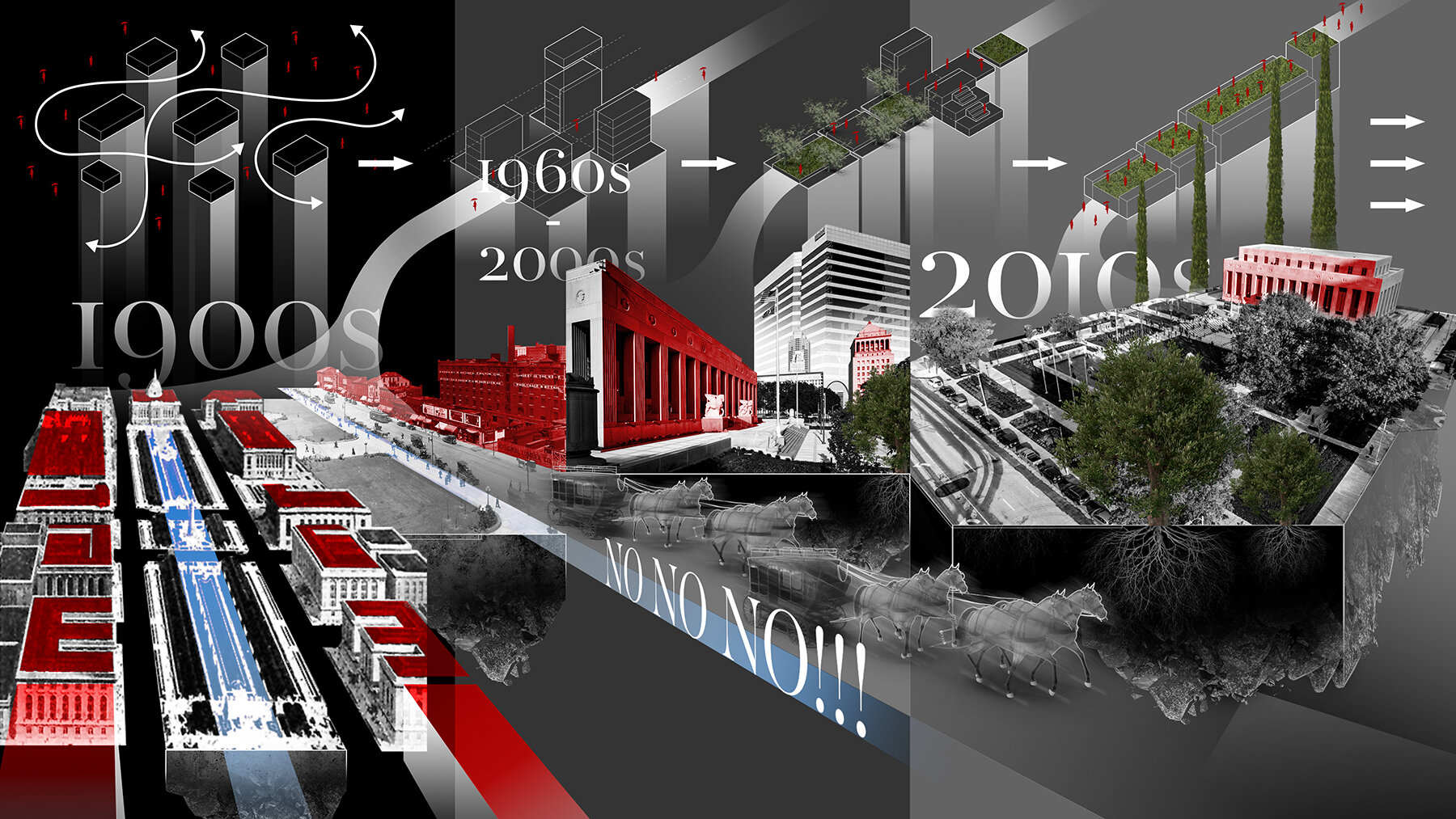
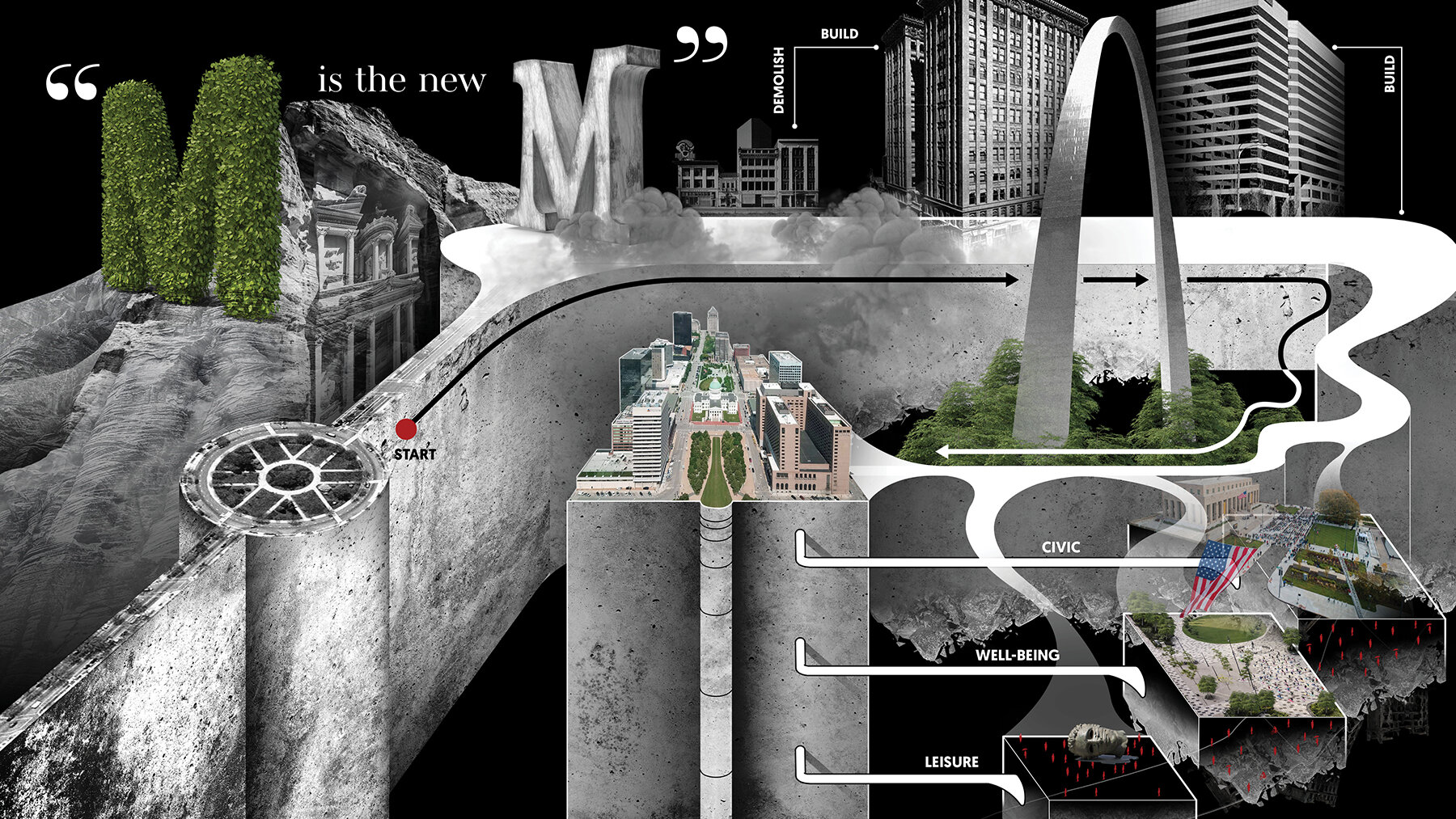
Chinh Pham’s Timegraph and Ideogram drawings explore the history of monumentality in landscape architecture, especially in the Gateway Mall in St. Louis. The New Monumentality, he argues, is more green, less formal, and embraces emergence and novel expressions of ecological design.
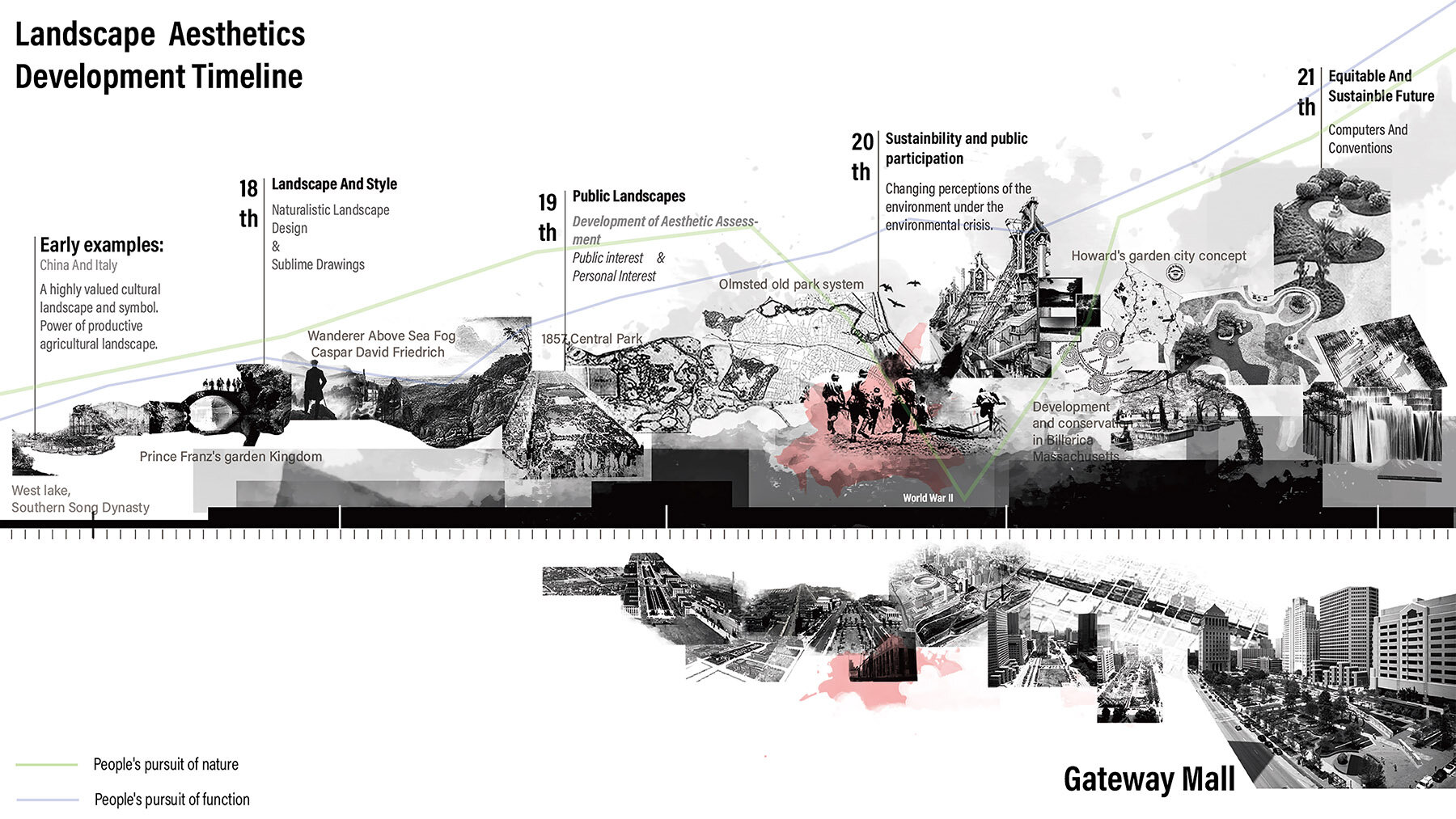
Niansong Zhang’s Timegraph and Ideogram drawings depict how aesthetics has shaped landscape architecture, and how one-sided, religious ideas about nature keep us from accepting the necessary, unaesthetic qualities of ecological processes.
Mapping
In conjunction the the course GIS for Site Design, the students make thematic maps on the continental, city, and neighborhood scale. The smallest scale crosses over to studio, where students use this to select for and argue for a particular site on or near the Gateway Mall in Downtown St. Louis. Students bring GIS data together with traced elements from historic and aerial maps. They include mobility systems like lightrail, bus, bicycle infrastructure, and pedestrian crosswalks. Students continue drawing until these maps represents what is important for their topic (developed through the Ideogram and Timegraph). What do the students see in these contexts? What is at stake here?
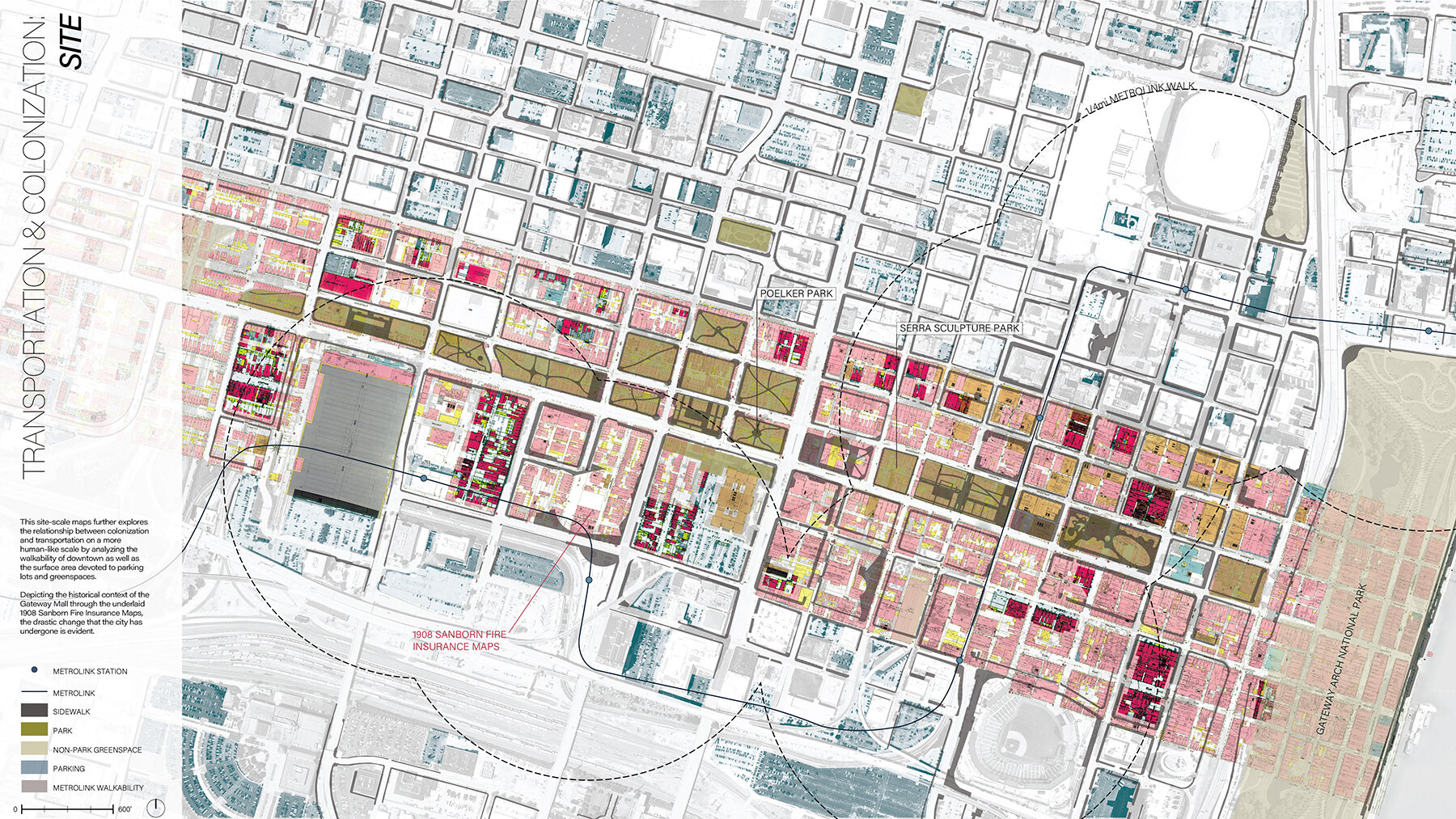
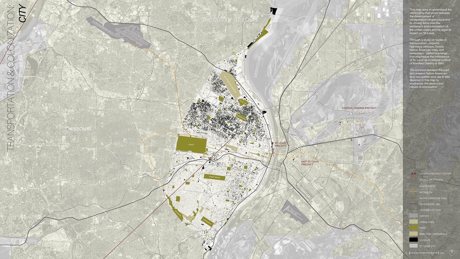
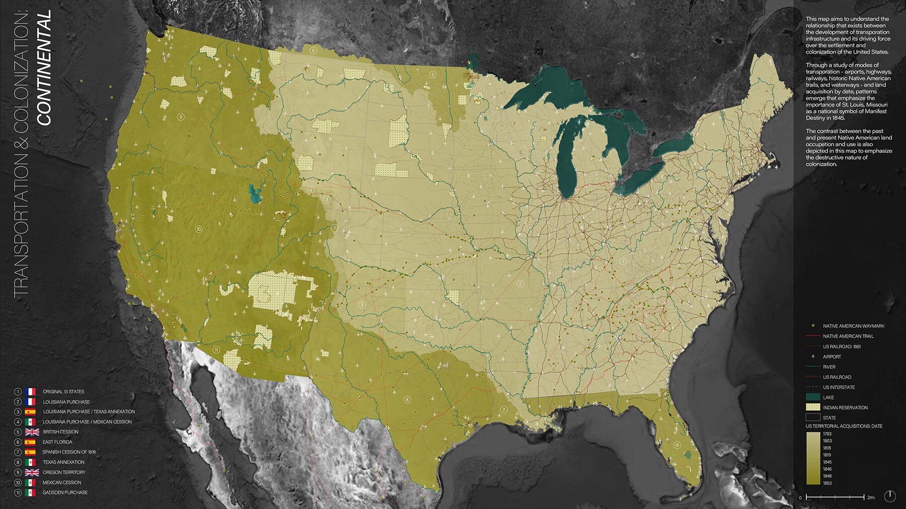
At the continental scale, Kaiti Burger’s map explores ‘Manifest Destiny.’ At the St. Louis scale, the expansion of the US city oftentimes grew along Indigenous trails and settlements. The Gateway Mall has a history of colonization and development for trade, as well as decolonization—or erasure—of urban fabric for the making of the Jefferson Expansion Memorial and the Gateway Mall. The Sanborn Fire Insurance maps tell us some of this many-layered history.
Site Studies
In conjunction with the course Digital Tools, students learned terrain visualization and analysis, producing site studies that could further inform their design of their selected sites.
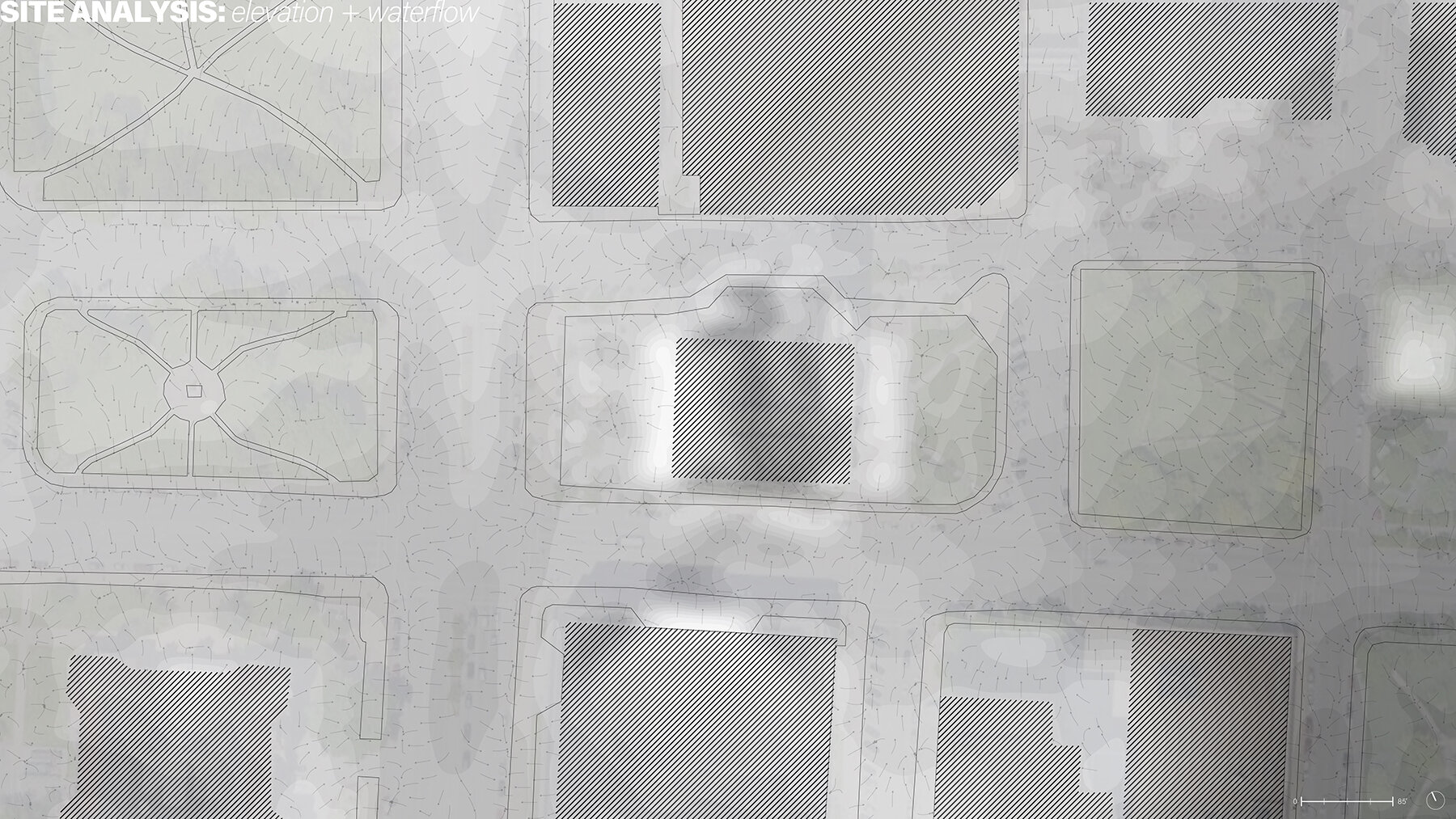
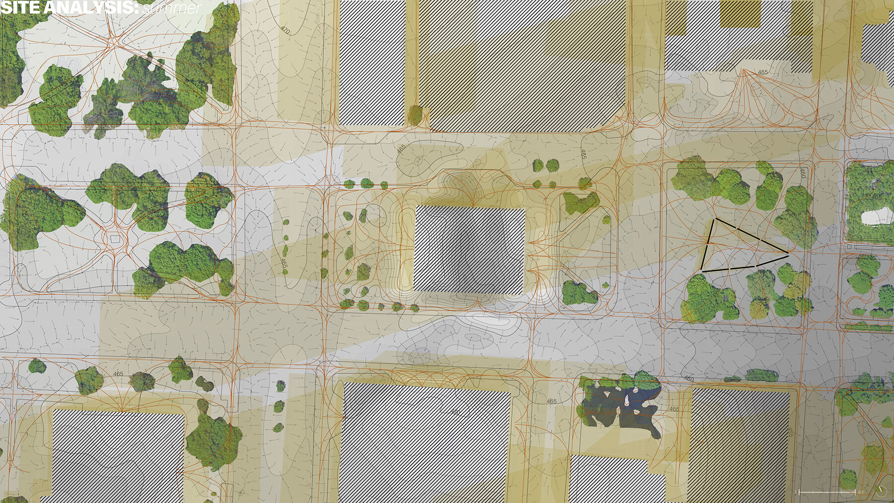
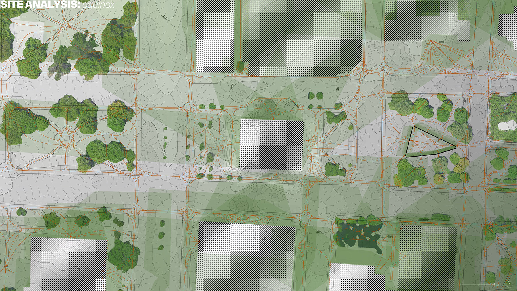
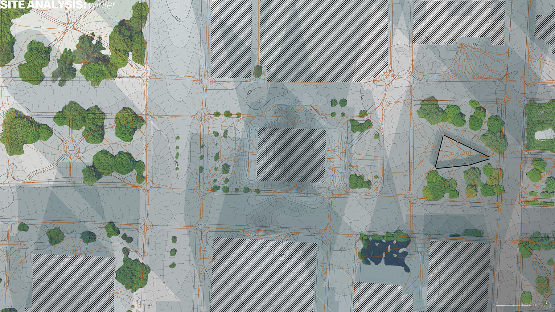
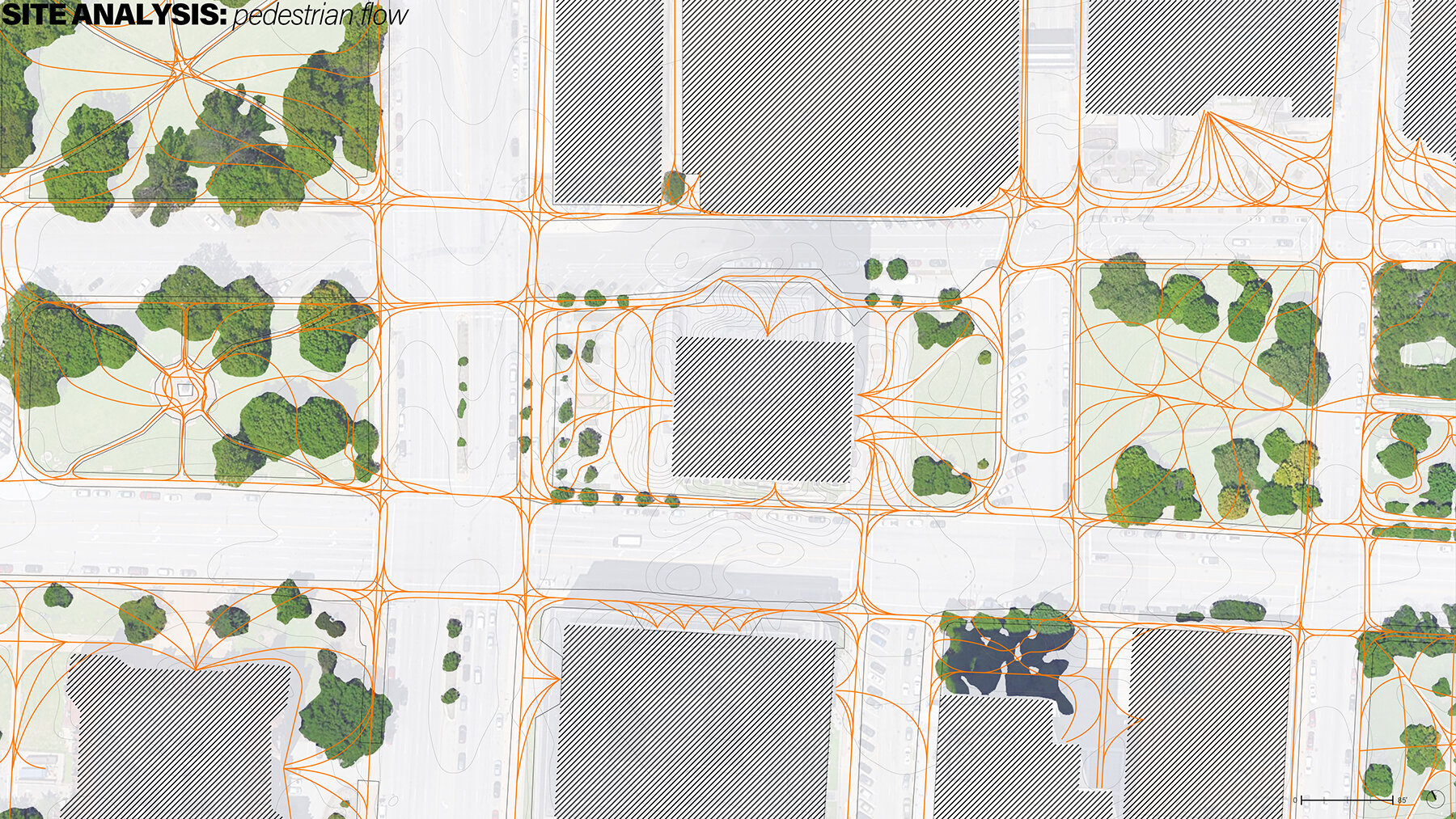
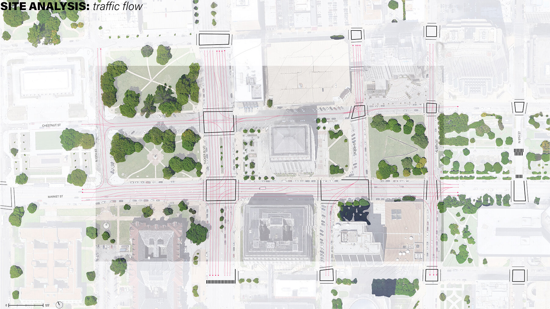
Kaiti’s site studies explore elevation, waterflow, traffic flow, pedestrian flow, and shadow study at the solstice and equinoxes.
If/Then Series
Students experiment with design ideas and some contingent futures to understand what would truly change, if you intervene in a particular way. Students take on 4 contingencies and produce a matrix of 16 drawings.

Niansong’s matrix explores how living and dead plants could have a place in her dialectical—aesthetic/unaesthetic landscape. She also explores ways that comfort of the path can be interrupted with cuts that open up the earth, beyond the expected ‘planting bed’ typology.

Chinh’s matrix tests how various parts of his episodic site design may evolve with the participation of visitors and vegetation growth over time. Seasonality and diurnal patters are also explored.
Thick Plan
Like landscape plans, the Thick Plan is a 2D representation where vertical information is layered. Students should depict a sense of ground, materiality, canopy, light/shadow, and as much as possible contains a sense of time. The time registered in the plan could be phasing, growth, season specificity, social activation, or ecological flux.

Kaiti's plan takes stock of the street infrastructure, and layers her design into the site from plants selected for the floor under a thick canopy of newly planted trees. The hardscape is articulated with many materials that mark past building and unbuilding, as well as visualizing contours and making human movement more clear.

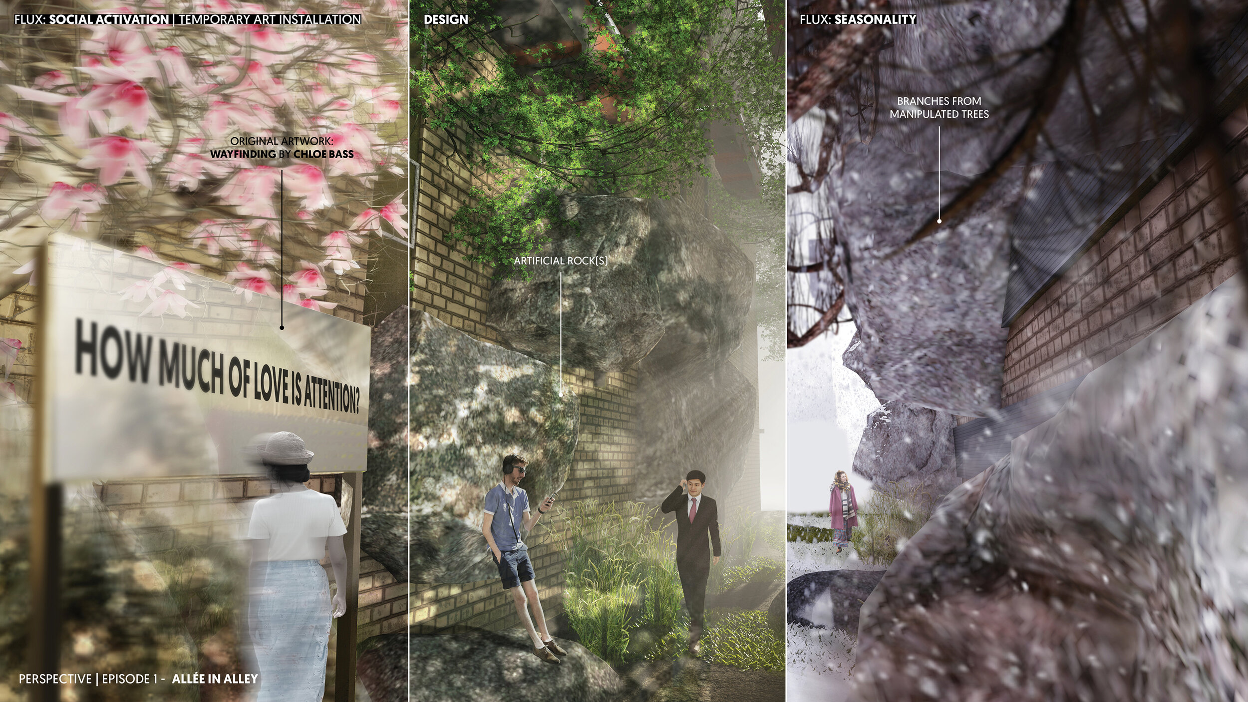
Chinh’s plan ties together his episodic site design, from the “Allée in Alley” to the streetscape, Serra Sculpture Park—where he reimagines the site around an early work of Richard Serra.
Serial Sections
These sections are meant to give an experiential sense of the project, while also registering other changes over time.
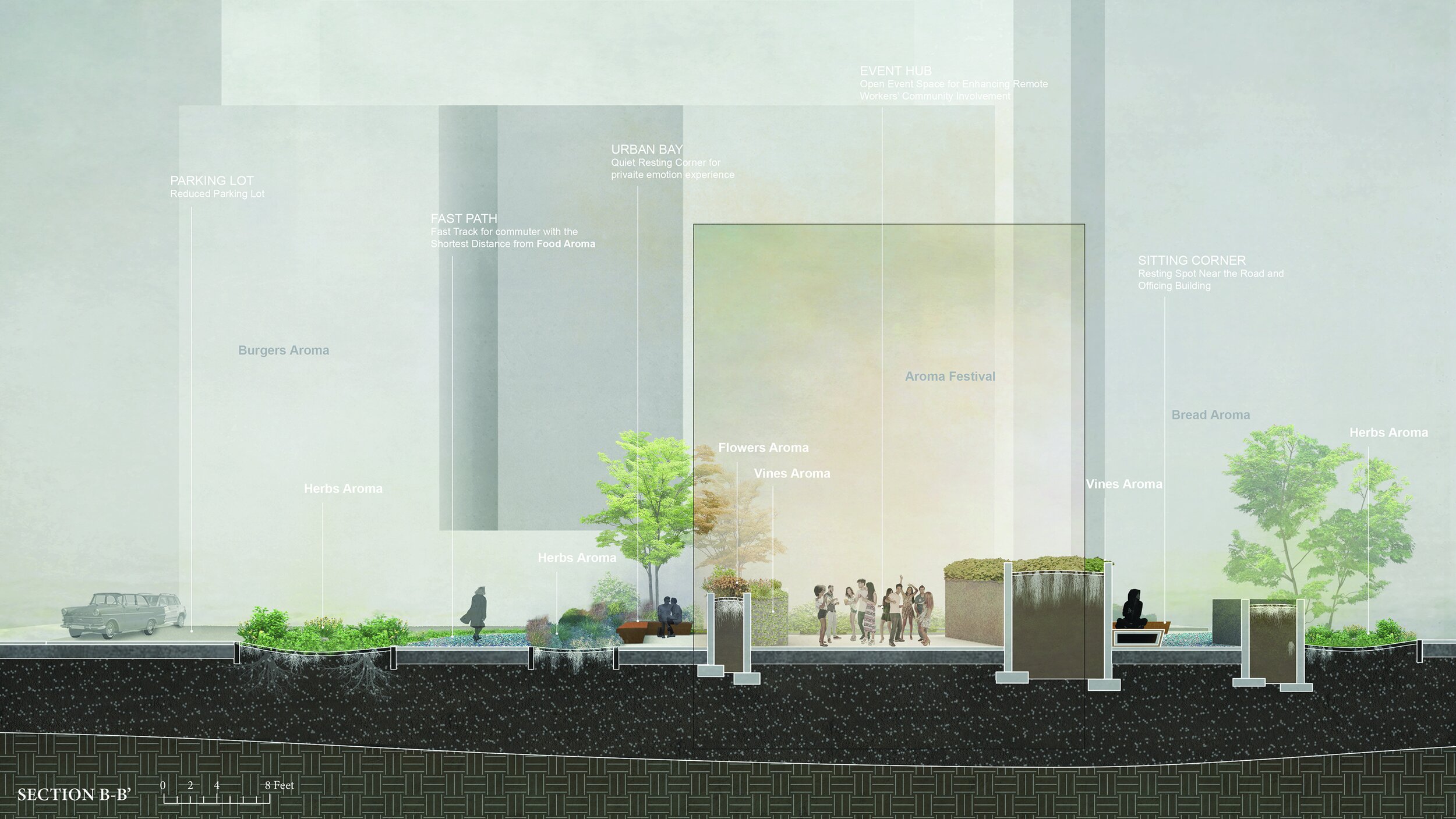
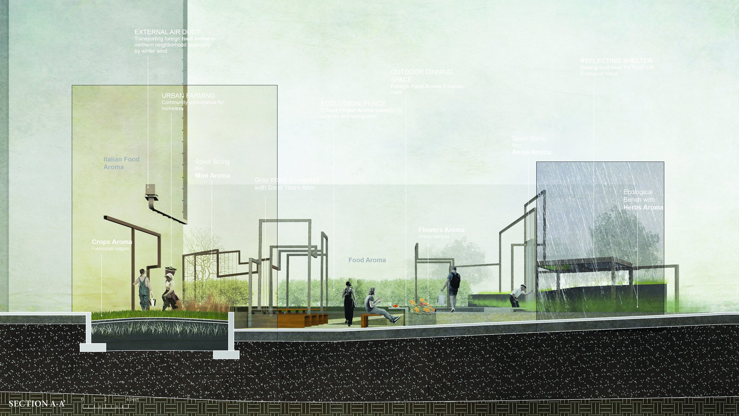
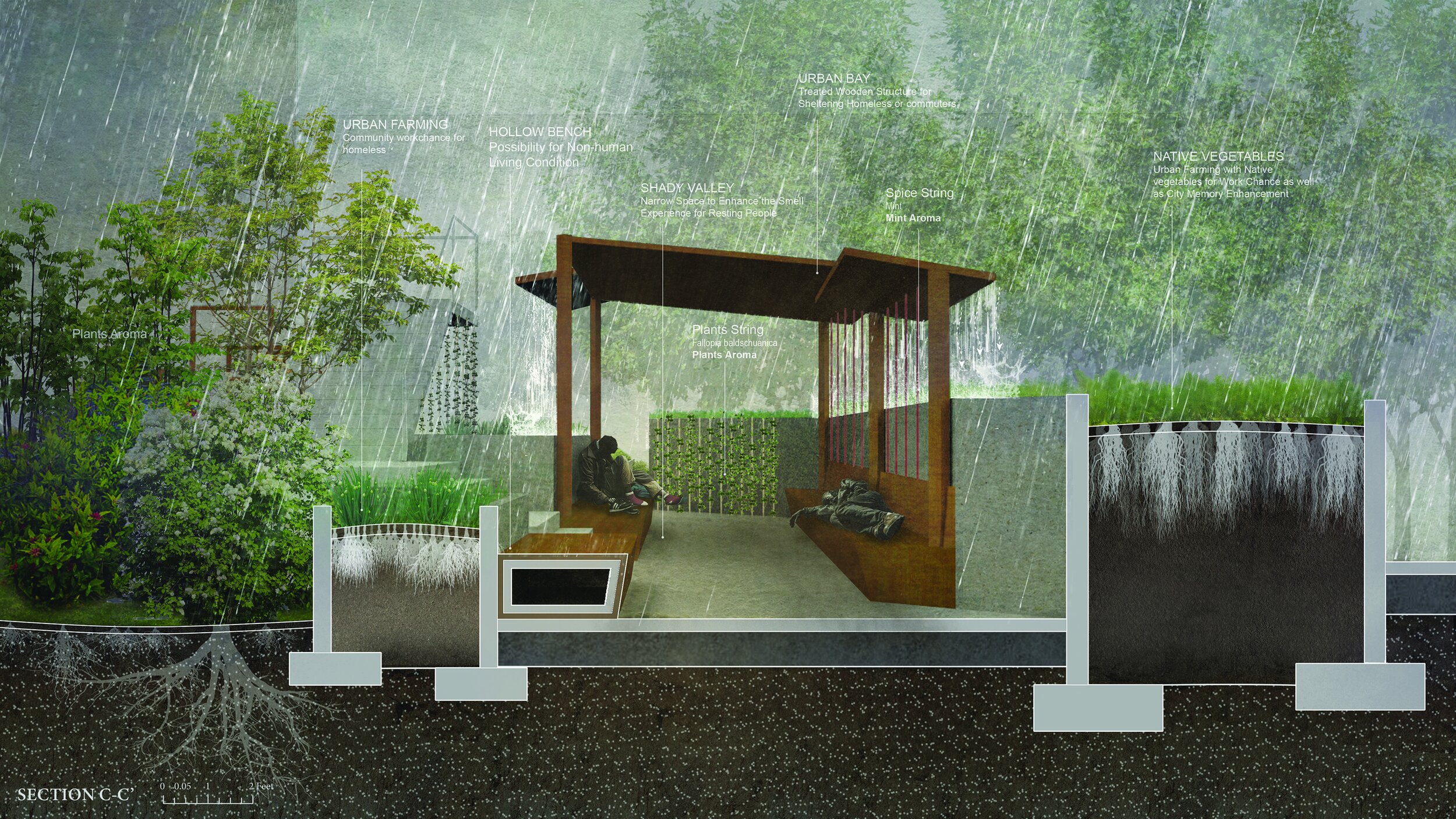
Jingyan Wang’s sections depict how her project—part streetscape and part pocket park—uses aromas from indigenous and non-native plants and makes an array of semi-private spaces to improve the conditions for the unemployed and the remote-working population.
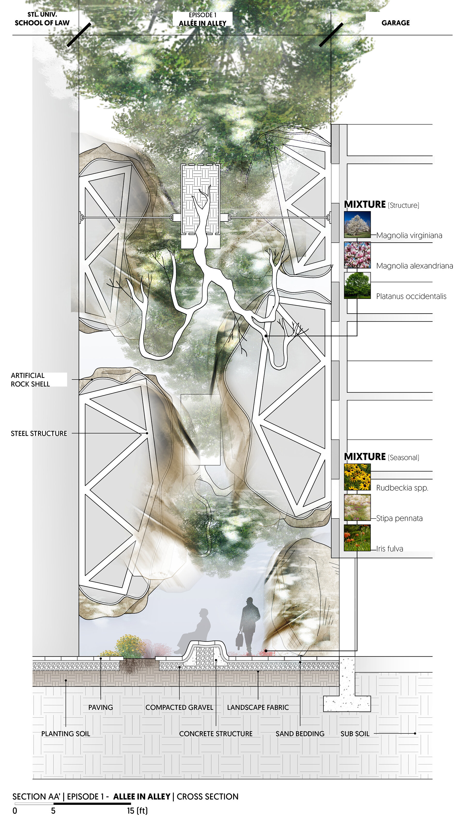
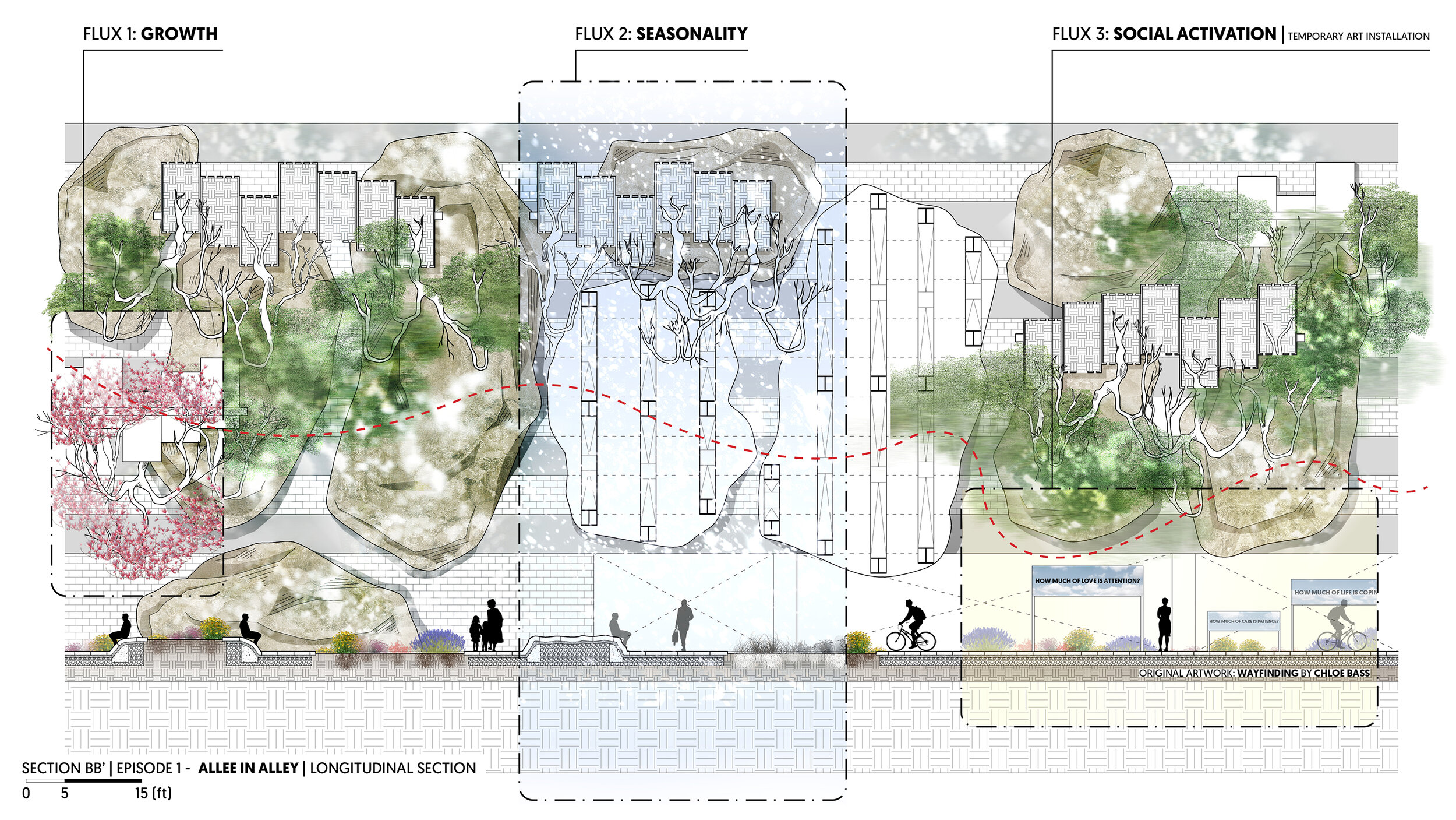
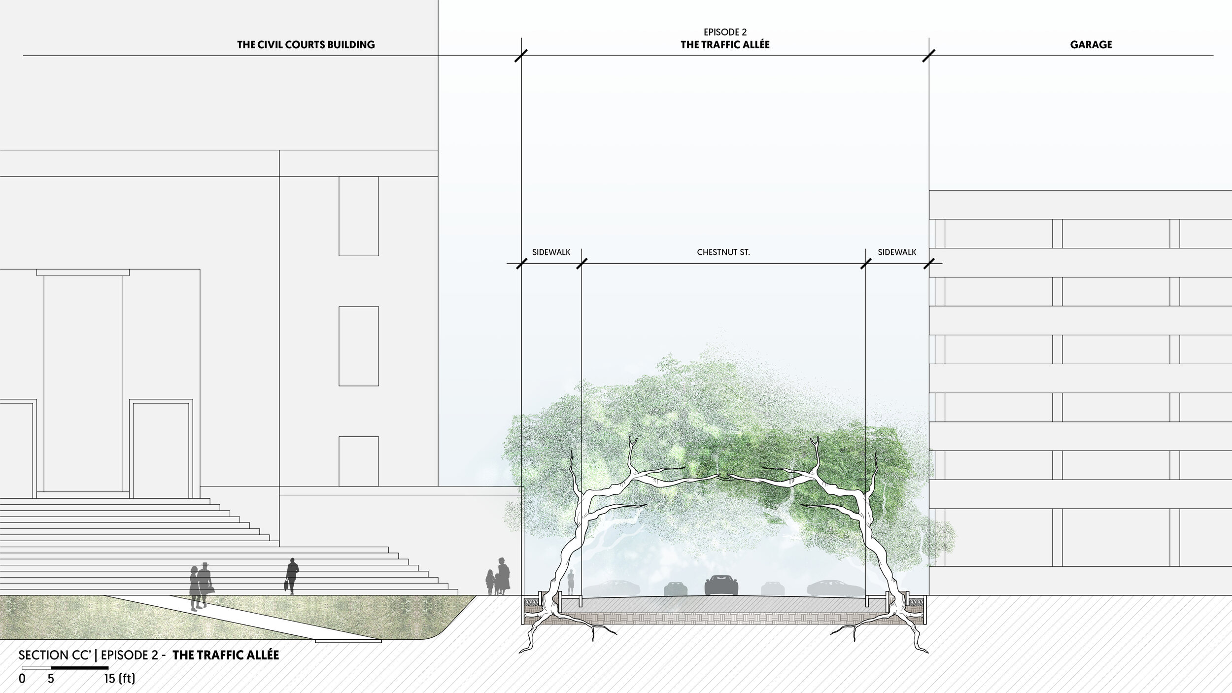
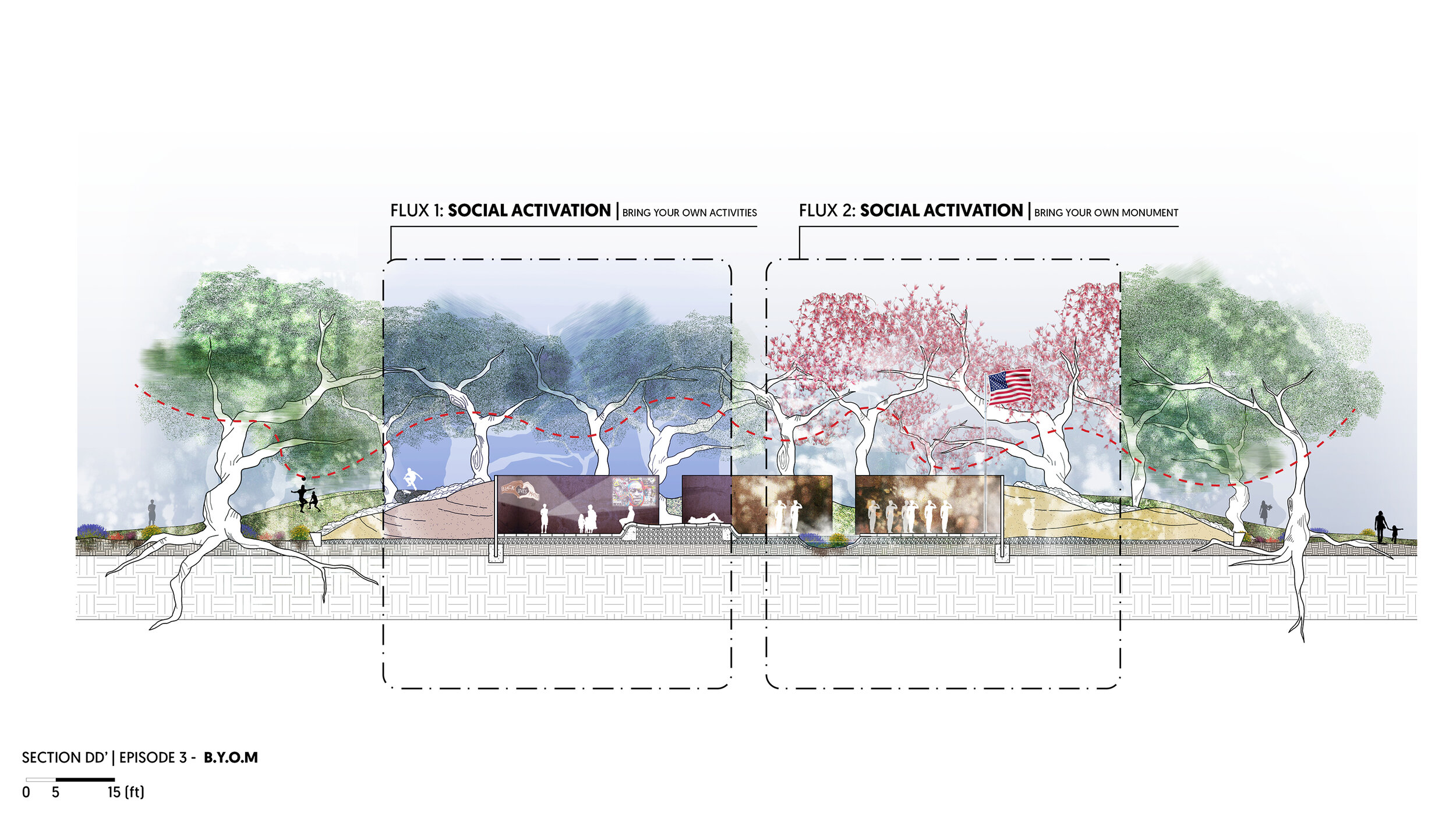
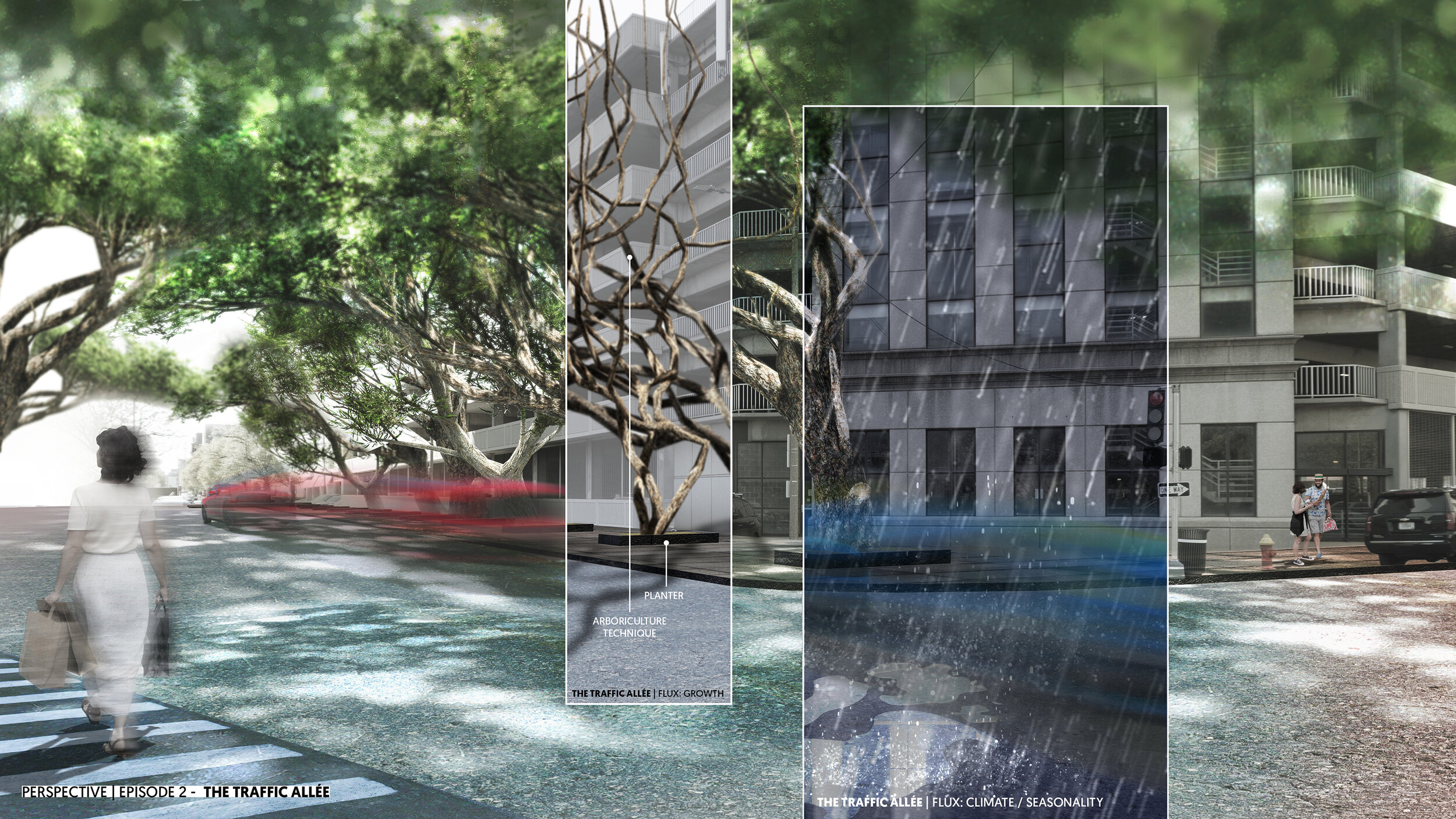
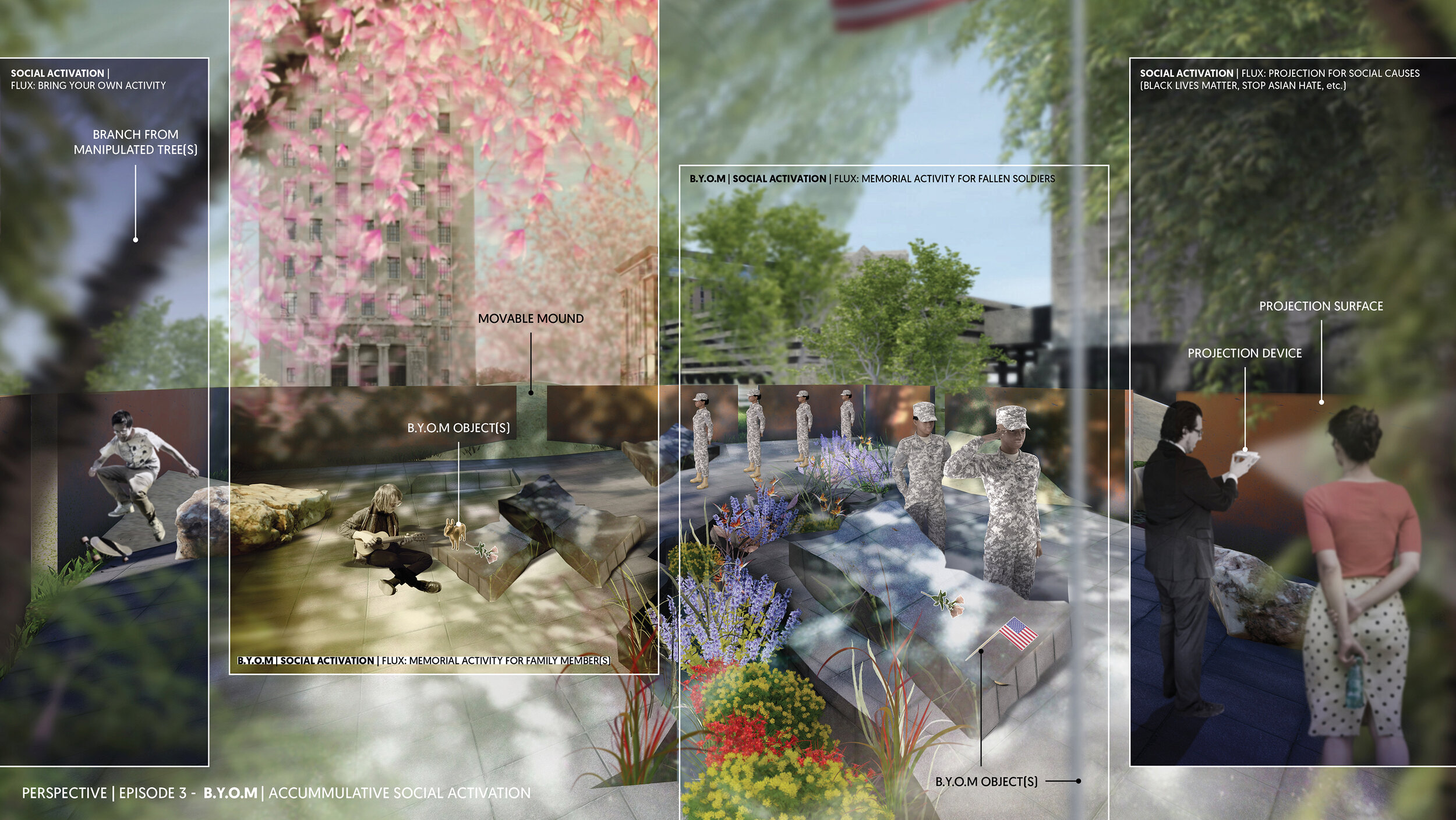
Chinh’s sections walk through the episodic nature of his design. The Allée in Alley episode makes ever-changing spaces between artificial boulders. Trees planted above, upside down, make for a unique interplay of dappled light and shadow. The streetscape, more subtle in nature, has trees planted along the street and trained to grow toward each other, multiplying the canopy and dappled light-and-shadow. At Serra Sculpture Park, sculptable sand pits that allow users to experience the Serra sculpture with a changing relationship with the ground. The rest of the space inside the sculpture is open and flexible for users to ‘bring-your-own-monument,’ a process that occurs by the placement of objects, performance, or through multi-media display.
Augmented Model
As a virtual studio, with most students away from the campus facilities, this model exercise allowed everyone to explore how digital model visualizations and physical models are beginning to blur.

Chinh’s Augmented Model visualizes how the tight tree canopy ties the episodic site design together, as the project moves from the park on the Gateway Mall to the streetscape, to the alley.
Generative Renderings
In conjunction with the course Digital Tools, this series features experiential perspectives of the project, while also adding one more chance to show how the project might be experienced through various contingencies over time.